The Unique Maps Co.
Old Map of Phoenix, Arizona by USGS, 1952 – Mesa, Tempe & Sky Harbor Airport
Old Map of Phoenix, Arizona by USGS, 1952 – Mesa, Tempe & Sky Harbor Airport
Couldn't load pickup availability
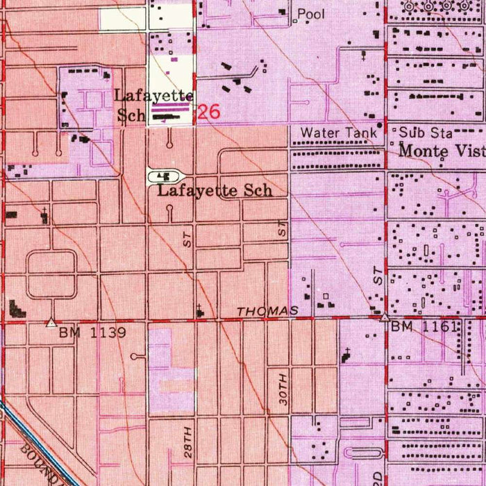
Published with a 1968 imprint from 1952 survey work, the US Geological Survey’s “Phoenix” captures the Arizona capital at a pivotal moment in its transformation from desert city to metropolitan powerhouse. At the precise 1:24,000 scale, the map records Phoenix and its surrounding communities with the disciplined clarity that made USGS quadrangles indispensable to planners, engineers, geologists, and travelers. Here the city is not yet the vast urban expanse familiar today, but a rapidly organizing landscape of gridded streets, rail corridors, irrigation-influenced settlement, airport infrastructure, and spreading residential districts. The title itself is succinct, almost understated, yet the sheet reveals a complex urban organism in motion: Phoenix poised between agricultural hinterland, desert topography, and the postwar forces of expansion.
The US Geological Survey, founded in 1879, became one of America’s most consequential mapping institutions, charged with measuring and interpreting the nation’s terrain, resources, and hazards. Its topographic maps were more than geographic records; they were tools of governance, development, and scientific understanding. This Phoenix sheet exemplifies the agency’s exacting cartographic language, using contour lines, standardized symbols, transportation markings, and carefully differentiated color to convey both natural and built environments. Shades of pink and purple emphasize developed areas and elevation-related detail, while the surrounding desert and agricultural lands are rendered with a quieter precision. The result is a map that is at once technical and visually compelling, a measured portrait of a city expanding across the Salt River Valley.
Phoenix’s mid-century geography is especially striking here. The Rio Salado, or Salt River, forms a defining natural corridor through the urban landscape, its broad wash and associated lowlands shaping settlement, transport, and land use. To the east and southeast, Tempe, Mesa, and Guadalupe appear as neighboring communities tied to Phoenix by roads, railways, and the shared logic of valley development. South Phoenix is visible as a distinct area within the broader metropolitan pattern, while residential neighborhoods and school districts speak to the demographic momentum of the postwar decades. Agricultural tracts remain present, reminding the viewer that Phoenix’s modern growth emerged from an irrigated desert economy before being transformed by highways, industry, and suburbanization.
Transportation infrastructure gives this map much of its historical energy. Phoenix Sky Harbor International Airport is shown as a major civic and commercial anchor, reflecting the growing importance of air travel to the city’s national connections. Interstate 10, Interstate 17, Route 60, and rail lines reveal a region increasingly structured by mobility, freight, and long-distance circulation. These corridors helped convert Phoenix from a regional desert city into a crucial node in the American Southwest. The map also records parks, public facilities, schools, and recreational spaces, showing how civic infrastructure accompanied urban growth. Papago Park, with its distinctive desert landscape and geological formations, provides a natural counterpoint to the rectilinear order of streets and subdivisions.
As a historical document, this map is particularly evocative because it preserves Phoenix before later waves of explosive metropolitan expansion blurred the boundaries between city, suburb, and desert. The contour lines quietly articulate the basin-and-range setting, grounding the urban grid within a larger physical geography of alluvial plains, low hills, and arid washes. Its symbols distinguish rural land, water features, public institutions, and built-up neighborhoods with remarkable economy, allowing the viewer to read both the city’s form and its future direction. For collectors, urban historians, and admirers of Southwestern landscapes, the sheet offers a richly detailed snapshot of Phoenix at mid-century: ambitious, expanding, and already beginning to assume its role as one of the defining cities of the modern American desert.
Cities, towns and places on this map
- Phoenix
- South Phoenix
- Mesa
- Tempe
- Guadalupe
- Rio Salado / Salt River
- Papago Park
- Phoenix Sky Harbor International Airport
- Interstate 10
- Interstate 17
- Route 60
- Railways
- Residential neighborhoods
- Parks and recreational areas
- Historic sites
- School districts
- Agricultural areas
- Schools and public facilities
Historical context & cartographic details
- Historical 1:24,000 topographical map of Phoenix, Arizona and its surroundings.
- Created in 1952, with a published imprint in 1968.
- Produced by the US Geological Survey, a U.S. government scientific agency known for mapping and surveying.
- Captures Phoenix during a period of rapid mid-20th-century urban development.
- Shows the transformation of the region from a smaller settlement into a major city with expanding infrastructure.
- Uses distinct USGS-style color coding, including shades of pink and purple, to represent land uses and elevation.
- Features contour lines indicating elevation, landforms, and the topographic character of the Phoenix area.
- Uses colors and symbols to distinguish urban areas, rural land, bodies of water, and other significant features.
Looking for a particular place? Review the detailed images to confirm that the town, landmark or feature you have in mind appears on the map. If you are unsure, ask our workshop to check before you order.
Detailed maps are especially rewarding at larger sizes, where names, boundaries and decorative features have more room to be appreciated. Use the close-up preview and size guide to choose the right scale for your wall.
This map looks amazing at sizes all the way up to 50in (125cm). If you are looking for a larger map, please get in touch.
The model in the listing images is holding the 16x20in (40x50cm) version of this map.
Where personalisation is available, you can add a short title or dedication, mark one meaningful place, or request one considered visual detail. See personalised map examples.
Every piece is printed to museum-grade archival standards using fade-resistant pigment inks on acid-free matte paper. Choose an unframed map print, framed map or canvas using the finish options above. Framed maps use crystal-clear optical acrylic and arrive ready to hang.
With its rich detail and strong sense of place, this map makes a considered gift for a new home, anniversary, retirement or anyone with a personal connection to the area shown. Still deciding? Explore our collection of rare old and vintage maps to discover another place, period or style.
Share