The Unique Maps Co.
Old Map of Fountain Hills, Arizona by USGS, 1906 – Fort McDowell, Salt River & McDowell Mountains
Old Map of Fountain Hills, Arizona by USGS, 1906 – Fort McDowell, Salt River & McDowell Mountains
Couldn't load pickup availability
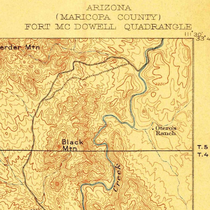
Published in 1906, the U.S. Geological Survey’s “Ft. McDowell” presents the desert landscape northeast of Tempe with the precision and quiet drama characteristic of early federal topographic mapping. Issued at a scale of 1:62,500 under the directorship of Charles D. Walcott, the map records the terrain around Fort McDowell, the Salt River, and the area that would later become Fountain Hills. Its finely drawn contours reveal a rugged world of ridges, washes, and valley floors, while blue hydrographic lines emphasize the importance of water in this arid country. More than a geographic document, it is a portrait of central Arizona before modern suburban expansion, highways, and reservoirs transformed the region.
The U.S. Geological Survey, founded in 1879, became one of the great scientific mapping institutions of the United States, tasked with understanding the nation’s lands, minerals, watersheds, and topography. By 1906, its quadrangles were essential tools for engineers, land managers, settlers, soldiers, and scientists alike. “Ft. McDowell” reflects this mission with disciplined clarity: contour lines, drainage patterns, roads, trails, and reservation boundaries are all rendered as parts of a coherent landscape system. Walcott’s tenure at the USGS was marked by an emphasis on scientific rigor, and maps such as this one helped translate remote or rapidly changing regions into legible, measurable terrain at a moment when Arizona was still a territory.
The map’s visual language is especially appealing: warm brown contour lines model the land’s relief, while blue waterways trace the Salt River and its tributary washes through the desert. This restrained palette gives the map both elegance and utility, allowing the viewer to read the shape of the McDowell Mountains, Usery Mountain, and surrounding valleys with remarkable immediacy. An ornate compass rose and scale indicator add a refined cartographic flourish, balancing scientific function with period style. The close spacing of contours conveys the steep mountain fronts and broken uplands typical of the Sonoran Desert, while more open lines suggest gentler alluvial plains where later roads, settlements, and infrastructure would emerge.
Historically, the map is compelling for the way it captures a landscape on the edge of profound change. Fort McDowell and the nearby Indian Reservation anchor the sheet in the military, Indigenous, and administrative history of the Salt River Valley. Present-day Fountain Hills, now known for its planned residential setting and celebrated fountain, belonged then to a largely undeveloped desert environment shaped by topography, seasonal water, and travel routes. Tempe appears to the southwest as an established settlement in a growing agricultural valley, while the routes toward Apache Junction and the Superstition foothills hint at the wider network of movement across central Arizona before the dominance of automobile suburbs.
The Salt River is one of the map’s central features, both visually and historically. In 1906, the river corridor was still being understood as a vital resource for irrigation, settlement, and future water control; later dam projects would create familiar landmarks such as Saguaro Lake and Canyon Lake downstream in the region’s evolving reservoir system. Seen through this earlier topographic lens, the river is not merely a line of blue but the organizing force of the terrain, cutting through desert mountains and sustaining human possibility. Roads and trails depicted across the sheet speak to a transitional Arizona—part frontier, part scientific survey, and soon to become a landscape of ambitious development.
Cities, towns and places on this map
- Fountain Hills
- Fort McDowell
- Salt River
- Indian Reservation
- McDowell Mountains
- Tempe
- Apache Junction
- Usery Mountain
- Saguaro Lake
- Bush Highway
- Canyon Lake
- Various roads and trails depicted
- Metropolitan areas surrounding Fountain Hills
Historical context & cartographic details
- Produced by the U.S. Geological Survey, this historical 1:62,500 topographical map is dated 1906.
- The map was published under U.S. Geological Survey Director Charles D. Walcott.
- The USGS was established in 1879 and played a critical role in American mapping, geological research, land-use analysis, watershed management, and topographical surveying.
- The map provides insight into the early 20th-century landscape of Arizona, showing the region before later growth in population, infrastructure, and development.
- Brown and blue hues are used to distinguish topographic and hydrological information.
- Contour lines show elevation changes, valleys, hills, and mountainous terrain.
- The Salt River is emphasized as a major hydrological feature of the area.
- The map includes an ornate compass rose and a scale indicator, adding to its cartographic elegance.
Looking for a particular place? Review the detailed images to confirm that the town, landmark or feature you have in mind appears on the map. If you are unsure, ask our workshop to check before you order.
Detailed maps are especially rewarding at larger sizes, where names, boundaries and decorative features have more room to be appreciated. Use the close-up preview and size guide to choose the right scale for your wall.
This map looks amazing at sizes all the way up to 50in (125cm). If you are looking for a larger map, please get in touch.
The model in the listing images is holding the 16x20in (40x50cm) version of this map.
Where personalisation is available, you can add a short title or dedication, mark one meaningful place, or request one considered visual detail. See personalised map examples.
Every piece is printed to museum-grade archival standards using fade-resistant pigment inks on acid-free matte paper. Choose an unframed map print, framed map or canvas using the finish options above. Framed maps use crystal-clear optical acrylic and arrive ready to hang.
With its rich detail and strong sense of place, this map makes a considered gift for a new home, anniversary, retirement or anyone with a personal connection to the area shown. Still deciding? Explore our collection of rare old and vintage maps to discover another place, period or style.
Share